International District | |
|---|---|
Neighborhood of Albuquerque | |
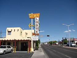
 The Tewa Lodge on Central Ave. | |
| Coordinates: 35°4′21″N 106°34′06″W / 35.07250°N 106.56833°W | |
| Country | United States |
| State | New Mexico |
| County | Bernalillo |
| City | Albuquerque |
| Government | |
| • City Council | Nichole Rogers |
| • State House | G. Andrés Romero (D) Debra M. Sariñana (D) Kay Bounkeua (D) |
| • State Senate | Antoinette Sedillo Lopez (D) Mimi Stewart (D) |
| • U.S. House | Melanie Stansbury (D) |
| Area | |
| • Total | 3.87 sq mi (10.0 km2) |
| Population (2010)[2] | |
| • Total | 29,796 |
| • Density | 7,699/sq mi (2,973/km2) |
| ZIP Code | 87108[1] |
| Area code | 505 |
The International District is a neighborhood in southeast Albuquerque, New Mexico. It is centered on Central Avenue, the historic alignment of U.S. Route 66, and contains the New Mexico State Fairgrounds. The community is one of the most diverse areas of the city and is home to a large number of international restaurants and grocery stores,[3] as well as the city's "Little Saigon" Vietnamese enclave.[4] It is also one of the poorest areas in the city and has an extremely high violent crime rate. Although re-branded by city officials as the International District in 2009, Albuquerque residents continue to refer to the neighborhood by its longtime nickname, The War Zone.
- ^ a b "Advanced Map Viewer". City of Albuquerque. Retrieved April 25, 2018.
- ^ "2010 Census Summary File 1, Table P1". U.S. Census Bureau. Retrieved April 25, 2018.
- ^ McKay, Dan (February 3, 2009). "Introducing the "International District"". Albuquerque Journal. Retrieved April 25, 2018.
- ^ "Culture & Heritage: Asian American". Visit Albuquerque. Retrieved April 25, 2018.