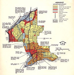
 1970 map of the proposed route of I-485 through northeast Atlanta | ||||
| Route information | ||||
| Auxiliary route of I-85 | ||||
| Length | 5.9 mi[1] (9.5 km) | |||
| Existed | 1964[citation needed]–1975[2] | |||
| NHS | Entire route | |||
| Location | ||||
| Country | United States | |||
| State | Georgia | |||
| Counties | Fulton | |||
| Highway system | ||||
| ||||
| ||||
| ||||
Interstate 485 (I-485) was a proposed auxiliary Interstate Highway that would have traveled eastward and then northward from Downtown Atlanta, in the US state of Georgia.
- ^ "Part V - Interstate Withdrawal-Substitution Program - Engineering Data - Interstate System - Highway History". Federal Highway Administration. Retrieved July 15, 2016.
- ^ Georgia Department of Transportation (January 1975). Official Highway Map (PDF) (Map) (1975–1976 ed.). Scale not given. Atlanta: Georgia Department of Transportation. Retrieved July 30, 2016.
