| Interstate Park | |
|---|---|
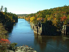
 The Dalles of the St. Croix River seen from the Wisconsin bank | |
| Location | United States |
| Coordinates | 45°23′30″N 92°39′55″W / 45.39167°N 92.66528°W |
| Area | 1,628 acres (6.59 km2) |
| Elevation | 886 ft (270 m)[1] |
| Established | 1895 |
| Governing body | Minnesota Department of Natural Resources, Wisconsin Department of Natural Resources |
Interstate State Park WPA/Rustic Style Historic District | |
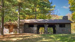
 1939 Refectory built by the WPA, now the Minnesota park's visitor center | |
| Location | Off U.S. Hwy. 8, Shafer Township |
|---|---|
| Nearest city | Taylors Falls, Minnesota |
| Coordinates | 45°24′0″N 92°39′4″W / 45.40000°N 92.65111°W |
| Area | 6 acres (2.4 ha) |
| Built | c. 1920–1939 |
| Architectural style | National Park Service rustic |
| MPS | Minnesota State Park CCC/WPA/Rustic Style MPS |
| NRHP reference No. | 89001664 |
| Added to NRHP | June 11, 1992 |
Interstate State Park CCC/WPA/Rustic Style Campground | |
 1938 Shelter/Refectory built by the WPA | |
| Location | Off US 8 SW of Taylors Falls, Shafer Township |
|---|---|
| Nearest city | Taylors Falls, Minnesota |
| Coordinates | 45°23′33″N 92°40′8″W / 45.39250°N 92.66889°W |
| Area | 22 acres (8.9 ha) |
| Built | 1938, 1941 |
| Architectural style | National Park Service rustic |
| MPS | Minnesota State Park CCC/WPA/Rustic Style MPS |
| NRHP reference No. | 92000638 |
| Added to NRHP | June 11, 1992 |
Interstate Park comprises two adjacent state parks on the Minnesota–Wisconsin border, both named Interstate State Park. They straddle the Dalles of the St. Croix River, a deep basalt gorge with glacial potholes and other rock formations. The Wisconsin park is 1,330 acres (538 ha) and the Minnesota park is 298 acres (121 ha). The towns of Taylors Falls, Minnesota and St. Croix Falls, Wisconsin are adjacent to the park. Interstate Park is within the Saint Croix National Scenic Riverway and the Ice Age National Scientific Reserve. The western terminus of the Ice Age National Scenic Trail is on the Wisconsin side. On the Minnesota side, two areas contain National Park Service rustic style buildings and structures that are listed on the National Register of Historic Places.
- ^ "Interstate State Park". Geographic Names Information System. United States Geological Survey. January 11, 1980. Retrieved February 25, 2011.


