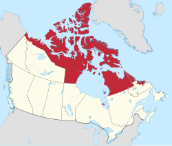
Inuit Nunangat
ᐃᓄᐃᑦ ᓄᓇᖓᑦ | |
|---|---|
Inuit Regions of Canada | |
 | |
| State | Canada |
| Regions | Inuvialuit Settlement Region, Nunavut, Nunavik, Nunatsiavut |
| Province / Territory | YT, NT, NU, QC, NL |
| Area | |
• Total | 3,304,740 km2 (1,275,970 sq mi) |
| • Land | 2,484,591 km2 (959,306 sq mi) |
| • Water | 820,149 km2 (316,661 sq mi) |
| Population (2021)[1] | |
• Total | 58,220 |
| • Density | 0.018/km2 (0.046/sq mi) |
| Ethnicity population | |
| • Inuit | 48,695 |
| • First Nations | 980 |
| • Métis | 325 |
| • Other Indigenous | 500 |
| • Non-Aboriginal | 7,715 |
| Time zone | UTC−08:00 (PST) UTC−07:00 (MST) UTC−06:00 (CST) UTC−05:00 (EST) UTC−04:00 (AST) |
| • Summer (DST) | Varies |
| Inuit languages (west to east) | Inuvialuktun Inuinnaqtun Inuktitut Inuit Sign Language (Atgangmuurngniq) Inuttitut |
| Website | www |
Inuit Nunangat (/ˈɪnjuɪtˈnunæŋæt/; Inuktitut syllabics: ᐃᓄᐃᑦ ᓄᓇᖓᑦ /inuit nunaŋat/; translated as "the place where Inuit live"[2]) refers to the land, water, and ice of the homeland of Inuit in Canada. This Arctic homeland consists of four northern Canadian regions called the Inuvialuit Settlement Region (Inuvialuit Nunangit Sannaiqtuaq, home of the Inuvialuit and the northern portion of the Northwest Territories and Yukon), the territory Nunavut (ᓄᓇᕗᑦ), Nunavik (ᓄᓇᕕᒃ) in northern Quebec, and Nunatsiavut of Newfoundland and Labrador.