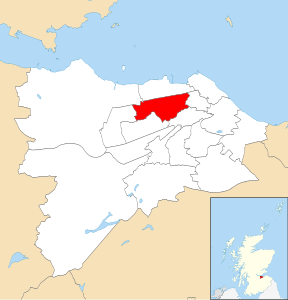
Inverleith is one of the seventeen wards used to elect members of the City of Edinburgh Council.[2] Established in 2007 along with the other wards, it currently elects four Councillors.
It covers an area to the north-west of the city centre, with the northern boundary mostly on Ferry Road and much of the southern boundary formed by the Water of Leith (the main exception being the Stockbridge neighbourhood on its right bank), including Blackhall, Comely Bank, Craigleith, Dean Village, Drylaw, Inverleith, Orchard Brae and Warriston,[3] as well as part of Canonmills which is split with the Leith Walk ward. Although its residential parts are mostly fairly compact and densely populated, the ward also includes several open areas, including the Royal Botanic Gardens Edinburgh, three cemeteries, a golf course and playing fields for numerous schools. A minor 2017 boundary change saw the loss of a residential area (between Roseburn Footpath and Stewart's Melville College) with a negligible effect on the population, which in 2019 was recorded at 34,236.[4]
- ^ "Map of City of Edinburgh wards, councillors and MSPS".
- ^ "United Kingdom: Scotland | Council Areas and Electoral Wards". City Population. 30 June 2019. Retrieved 28 March 2021.
- ^ News Index Archived 4 March 2021 at the Wayback Machine, Edinburgh Liberal Democrats
- ^ Electoral Ward: Inverleith, Scottish Government Statistics
