| Inyo Mountains | |
|---|---|
 Inyo Mountains from space | |
| Highest point | |
| Peak | Waucoba Mountain[1], ~18 mi (29 km) southeast of Big Pine. |
| Elevation | 11,123 ft (3,390 m) |
| Coordinates | 36°10′00″N 118°00′03″W / 36.16667°N 118.00083°W |
| Dimensions | |
| Length | 70 mi (110 km) |
| Width | 10 mi (16 km) |
| Geography | |
| Country | United States |
| States |
|
| Parent range | Basin and Range Province |
| Borders on | White Mountains, Sierra Nevada |
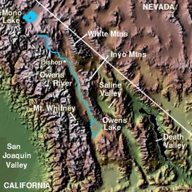
The Inyo Mountains are a short mountain range east of the Sierra Nevada in eastern California in the United States.[2] The range separates the Owens Valley to the west from Saline Valley to the east, extending for approximately 70 miles (110 km) south-southeast from the southern end of the White Mountains, from which they are separated by Westgard Pass, to the east of Owens Lake.
Geologically, the mountains are a fault block range in the Basin and Range Province, at the western end of the Great Basin. They are considered to be among the most important and best-known Late Proterozoic to Cambrian sections in the United States.[3]
- ^ "Waucoba Mountain". Geographic Names Information System. United States Geological Survey, United States Department of the Interior. Retrieved 2009-05-03.
- ^ "Inyo Mountains". Geographic Names Information System. United States Geological Survey, United States Department of the Interior. Retrieved 2009-05-03.
- ^ Localities of the Cambrian: White-Inyo Mountains


