Ipatinga | |
|---|---|
| Municipality of Ipatinga | |
| Motto(s): Confiança, Trabalho, Progresso "Confidence, Labour, Progress" | |
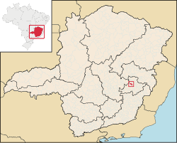
 Location in Minas Gerais | |
| Country | |
| State | |
| Region | Southeast |
| Intermediate Region | Ipatinga |
| Immediate Region | Ipatinga |
| Founded | 29 April 1964 |
| Government | |
| • Mayor | Gustavo Morais Nunes (PSL) |
| Area | |
• Total | 164.884 km2 (63.662 sq mi) |
| Elevation | 250 m (820 ft) |
| Population (2022)[2] | |
• Total | 227,731 |
| • Density | 1,400/km2 (3,600/sq mi) |
| Demonym | ipatinguense |
| Time zone | UTC−3:30 (MGT) |
| Postal Code | 35160-000 to 35169-999 |
| HDI (2010) | 0.771 – high[3] |
| Major airport | Vale do Aço Regional Airport |
| Passenger rail | Vitória-Minas Railway |
| Website | ipatinga |
Ipatinga is a municipality in eastern Minas Gerais state, Brazil. The city was founded on 29 April 1964 and covers a total area of 164.8 km2 (63.6 sq mi). Its population is 227,731 as of 2022. It is part of the Vale do Aço (Steel Valley) metropolitan area (population 430,700).
Ipatinga is at the site where the Piracicaba River flows into the Doce River. Located 217 km far from the state capital of Belo Horizonte, it is served by highway and railroad connections (Vitória-Minas Railway). There is also a medium-sized airport, Vale do Aço Regional Airport,[4] in the area of the neighboring city Santana do Paraíso, that serves the Steel Valley and can receive small and medium-sized planes, including jets like the Boeing 737 and the Fokker 100.
- ^ "Ipatinga". Câmara Municipal de Ipatinga. Retrieved 2 February 2022.
- ^ "IBGE Ipatinga". IBGE. Retrieved 2 February 2022.
- ^ "Archived copy" (PDF). United Nations Development Programme (UNDP). Archived from the original (PDF) on 8 July 2014. Retrieved 1 August 2013.
{{cite web}}: CS1 maint: archived copy as title (link) - ^ "Portal do Cidadão - Prefeitura Municipal de Ipatinga". Archived from the original on 9 February 2006. Retrieved 23 January 2006.


