Irinjalakuda | |
|---|---|
| Irinjalakuda | |
|
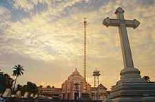
Clockwise from top: Koodalmanikyam Temple, Irinjalakuda Municipal Office, St. Thomas Cathedral, Civil Station | |
| Nickname: Varadanangalude Nadu | |
| Coordinates: 10°20′N 76°14′E / 10.33°N 76.23°E | |
| Country | |
| State | Kerala |
| District | Thrissur |
| Municipality | 1936 |
| Government | |
| • Type | Municipality |
| • Body | Irinjalakuda Municipal Council |
| • Chairperson | Suja Sanjeevkumar |
| Area | |
• Total | 33.57 km2 (12.96 sq mi) |
| Elevation | 39 m (128 ft) |
| Population (2011; after amalgamation with neighbouring Porathissery Grama Panchayath) | |
• Total | 62,521 |
| • Density | 1,900/km2 (4,800/sq mi) |
| Languages | |
| • Official | Malayalam, English |
| Time zone | UTC+5:30 (IST) |
| PIN | 680 121, 680 122, 680 125, 680 711, 680 712 |
| Telephone code | 0480 |
| Vehicle registration | KL-45 |
| Website | village |

Irinjalakuda is a municipal town in Thrissur district, Kerala, India. It is the headquarters of Irinjalakuda Revenue Division, Thrissur Rural Police and Mukundapuram Taluk. After Thrissur, this town has most number of administrative, law-enforcement, and judicial offices in the district. The place is well known for Koodalmanikyam Temple and the Thachudaya Kaimals,[1] who had princely status until 1971.[2] The earliest recorded history of this temples date back to the ninth century of Common Era (CE).
- ^ "Daily News with the Gulf Today on GoDubai, Middle East, Dubai, UAE Online News". Archived from the original on 15 April 2016. Retrieved 14 November 2017.
- ^ "The Koodalmanickam Devaswom Act, 1971" (PDF).


