Irish Channel
Manche irlandaise Cuisle na hÉireann | |
|---|---|
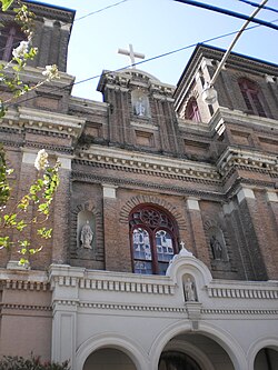
 St. Alphonsus Church on Constance Street in the original Irish Channel | |
 | |
| Coordinates: 29°55′23″N 90°04′55″W / 29.92306°N 90.08194°W | |
| Country | United States |
| State | Louisiana |
| City | New Orleans |
| Planning District | District 2, Central City/Garden District |
| Area | |
• Total | 0.83 sq mi (2.1 km2) |
| • Land | 0.50 sq mi (1.3 km2) |
| • Water | 0.33 sq mi (0.9 km2) |
| Elevation | 7 ft (2 m) |
| Population (2010) | |
• Total | 1,907 |
| • Density | 2,300/sq mi (890/km2) |
| Time zone | UTC-6 (CST) |
| • Summer (DST) | UTC-5 (CDT) |
| Area code | 504 |
Irish Channel (French: Manche irlandaise, Irish: Cainéal na hÉireann) is a neighborhood of the city of New Orleans. It is a subdistrict of the Central City/Garden District Area. Although the original site was located predominantly on the east side of Jackson Avenue, its boundaries as defined by the Historic District Landmarks Commission are: Magazine Street to the north, Jackson Avenue to the east, the Mississippi River to the south and Delachaise Street to the west.