| Irish Sea | |
|---|---|
 Satellite image | |
 Limits and ports: ◘ ferry port / ◘ freight only | |
| Location | Britain and Ireland |
| Coordinates | 53°30′N 5°00′W / 53.5°N 5.0°W |
| Type | Sea |
| River sources | Rivers that flow into the Irish Sea |
| Ocean/sea sources | Celtic Sea |
| Basin countries | United Kingdom; Republic of Ireland; Isle of Man |
| Max. width | 200 km (120 mi) |
| Surface area | 46,007 km2 (17,763 sq mi) |
| Average depth | 80–275 m (262–902 ft) |
| Water volume | 2,800 km3 (2.3×10⁹ acre⋅ft) |
| Islands | Anglesey and Holy Island, Isle of Man and Calf of Man, Bardsey Island, Walney, Lambay, Ireland's Eye |
| Settlements | (see below) |


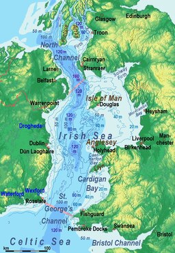
The Irish Sea[a] is a 46,007 km2 (17,763 sq mi) body of water that separates the islands of Ireland and Great Britain. It is linked to the Celtic Sea in the south by St George's Channel and to the Inner Seas off the West Coast of Scotland[4] in the north by the North Channel. Anglesey, North Wales, is the largest island in the Irish Sea, followed by the Isle of Man. The term Manx Sea may occasionally be encountered (Welsh: Môr Manaw, Irish: Muir Meann[5] Manx: Mooir Vannin, Scottish Gaelic: Muir Mhanainn).[6][7][8]
On its shoreline are Scotland to the north, England to the east, Wales to the southeast, Northern Ireland and the Republic of Ireland to the west. The Irish Sea is of significant economic importance to regional trade, shipping and transport, as well as fishing and power generation in the form of wind power and nuclear power plants. Annual traffic between Great Britain and Ireland is over 12 million passengers and 17 million tonnes (17,000,000 long tons; 19,000,000 short tons) of traded goods.
- ^ "Muir Éireann". téarma.ie – Dictionary of Irish Terms. Foras na Gaeilge and Dublin City University. Archived from the original on 10 May 2017. Retrieved 18 November 2016.
- ^ "Ellan Vannin" (in Manx). Centre for Manx Studies ("Laare-Studeyrys Manninagh"). Archived from the original on 4 March 2011. Retrieved 8 July 2011.
- ^ Cambridge Medieval Celtic Studies, Issues 33–35 University of Cambridge (Gran Bretaña). Department of Anglo-Saxon, Norse and Celtic 1997
- ^ Cite error: The named reference
IHOwas invoked but never defined (see the help page). - ^ "Electronic Dictionary of the Irish Language". Archived from the original on 27 January 2023. Retrieved 28 March 2021.
- ^ Bannerman, David Armitage (1963). The Birds of the British Isles: Volume 12. Edinburgh: Oliver and Boyd. p. 84. OCLC 725928669.
- ^ "The Caledonian". The Caledonian. 4. New York: Caledonian Publishing Co.: 25 1903.
- ^ "Irish Sea Facts". Irish Sea Conservation. Archived from the original on 11 May 2011. Retrieved 3 July 2011.
Cite error: There are <ref group=lower-alpha> tags or {{efn}} templates on this page, but the references will not show without a {{reflist|group=lower-alpha}} template or {{notelist}} template (see the help page).