Irmo, South Carolina | |
|---|---|
 | |
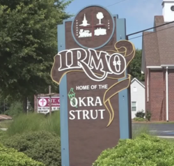
| Motto(s): "Gateway to Lake Murray and Home of the Okra Strut" | |
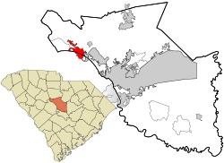
 Location in Richland County and the state of South Carolina. | |
| Coordinates: 34°05′10″N 81°10′59″W / 34.08611°N 81.18306°W | |
| Country | United States |
| State | South Carolina |
| Counties | Lexington, Richland |
| Incorporated | December 24, 1890 |
| Named for | C.J. Iredell and H.C. Mosely[1] |
| Government | |
| • Mayor | Bill Danielson |
| • Town Administrator | Courtney Dennis |
| Area | |
• Total | 6.86 sq mi (17.77 km2) |
| • Land | 6.86 sq mi (17.77 km2) |
| • Water | 0.00 sq mi (0.00 km2) |
| Elevation | 358 ft (109 m) |
| Population | |
• Total | 11,569 |
| • Density | 1,660.54/sq mi (641.10/km2) |
| Time zone | UTC-5 (EST) |
| • Summer (DST) | UTC-4 (EDT) |
| ZIP code | 29063 |
| Area code(s) | 803, 839 |
| FIPS code | 45-35890[5] |
| GNIS feature ID | 1231420[3] |
| Demonym | Irmite |
| Website | www |
Irmo (/ˈərmoʊ/) is a town in Lexington and Richland counties, South Carolina, United States and a suburb of Columbia. It is part of the Columbia Metropolitan Statistical Area and is located 12 miles (19 km) northwest of the city center. The population of Irmo was 11,569 at the 2020 census.[4]
- ^ "Irmo". South Carolina Encyclopedia. Retrieved November 27, 2023.
- ^ "QuickFacts: Irmo town, South Carolina". United States Census Bureau. Retrieved February 17, 2024.
- ^ a b U.S. Geological Survey Geographic Names Information System: Irmo, South Carolina
- ^ a b "Census Population API". United States Census Bureau. Retrieved October 15, 2022.
- ^ "U.S. Census website". United States Census Bureau. Archived from the original on December 27, 1996. Retrieved January 31, 2008.

