| Ironstone Mountain | |
|---|---|
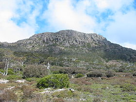
 Visually dominant slightly lower part of the mountain | |
| Highest point | |
| Elevation | 1,444 m (4,738 ft)AHD[1][2] |
| Prominence | 194 m (636 ft)[1] |
| Coordinates | 41°42′36″S 146°28′12″E / 41.71000°S 146.47000°E[3] |
| Geography | |
Location in Tasmania | |
| Location | Central Highlands, Tasmania, Australia |
| Parent range | Great Western Tiers |
| Topo map | Tasmap Lake Mackenzie (4438) 1:25000 |
| Geology | |
| Rock age | Jurassic |
The Ironstone Mountain is a mountain located in the Central Highlands region of Tasmania, Australia. Part of Great Western Tiers escarpment, the mountain is situated south of the small country village of Mole Creek.
With an elevation of 1,444 metres (4,738 ft) above sea level,[1] the mountain is the highest peak of the Great Western Tiers[2] and has a nearby companion lake, Lake Ironstone. The highest point is marked with a trig point, but more dominant is the slightly lower part of the mountain depicted here in the information box.
- ^ a b c "Ironstone Mountain, Australia". Peakbagger.com. Retrieved 31 May 2017.
- ^ a b Lloyd, Sarah (2012). The edge, a natural history of Tasmania's Great Western Tiers. Friends of Jacky's Marsh Inc. p. 1. ISBN 978-0-646-57082-2.
- ^ "Ironstone Mountain (TAS)". Gazetteer of Australia online. Geoscience Australia, Australian Government.
