Ironwood, Michigan | |
|---|---|
| City of Ironwood | |
 Downtown along Aurora Street (Bus. US 2) | |
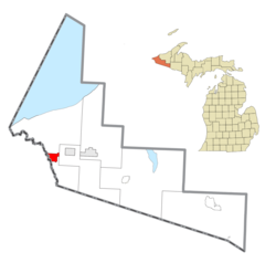
 Location within Gogebic County | |
| Coordinates: 46°27′21″N 90°9′34″W / 46.45583°N 90.15944°W | |
| Country | United States |
| State | Michigan |
| County | Gogebic |
| Settled | 1885 |
| Incorporated | 1887 (village) 1889 (city) |
| Government | |
| • Type | City commission |
| • Mayor | Kim Corcoran |
| • Mayor pro tem | David Andresen |
| Area | |
• Total | 6.58 sq mi (17.04 km2) |
| • Land | 6.58 sq mi (17.04 km2) |
| • Water | 0.00 sq mi (0.00 km2) |
| Elevation | 1,506 ft (459 m) |
| Population (2020) | |
• Total | 5,045 |
| • Density | 766.95/sq mi (296.13/km2) |
| Time zone | UTC−6 (Central (CST)) |
| • Summer (DST) | UTC−5 (CDT) |
| ZIP code(s) | 49938 |
| Area code | 906 |
| FIPS code | 26-41060[2] |
| GNIS feature ID | 0629087[3] |
| Website | Official website |

Ironwood is a city in Gogebic County in the Upper Peninsula of the U.S. state of Michigan, about 18 miles (29 km) south of Lake Superior. The city is on US Highway 2 across the Montreal River from Hurley, Wisconsin. It is the westernmost city in Michigan, situated on the same line of longitude (90.2 degrees West) as Clinton, Iowa and St. Louis, Missouri. The population was 5,045 at the 2020 census, down from 5,387 at the 2010 census. The city is bordered by Ironwood Township to the north, but the two are administered autonomously.
While originally an iron mining town, the area is now known for its downhill skiing resorts, including Big Powderhorn, Black River, Snow River, Mount Zion and Whitecap as well as its cross country skiing at the Wolverine Nordic Trail System and the ABR Nordic Center.
Ironwood is home of the "World's Tallest Indian," a 52 ft (15.8 m) fiberglass statue of tribal leader Hiawatha.
- ^ "2020 U.S. Gazetteer Files". United States Census Bureau. Retrieved May 21, 2022.
- ^ "U.S. Census website". United States Census Bureau. Retrieved January 31, 2008.
- ^ U.S. Geological Survey Geographic Names Information System: Ironwood, Michigan
