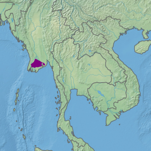
| Ecoregion: Irrawaddy freshwater swamp forests | |
|---|---|
 Maubin, in the Irrawaddy River Delta | |
 Ecoregion territory (in purple) | |
| Ecology | |
| Realm | Indomalayan |
| Biome | Tropical and subtropical moist broadleaf forests |
| Geography | |
| Area | 15,281 km2 (5,900 sq mi) |
| Country | Myanmar |
| Coordinates | 16°45′N 95°15′E / 16.75°N 95.25°E |
The Irrawaddy freshwater swamp forests ecoregion (WWF ID: IM0116) covers the freshwater portion of the delta of the Irrawaddy River, set back an average of 70 km from the Bay of Bengal by the saltwater mangroves. To the north is a rainforest belt with less inundated land. The region is extremely fertile due to the river-borne silt (the Irawaddy Delta is the fifth most heavily silted river in the world), but nearly-total conversion to agriculture has degraded the ecology. There are no fully protected areas in this ecoregion.[1][2][3][4]
- ^ "Irrawaddy freshwater swamp forests". World Wildlife Federation. Retrieved March 21, 2020.
- ^ "Map of Ecoregions 2017". Resolve, using WWF data. Retrieved September 14, 2019.
- ^ "Irrawaddy freshwater swamp forests". Digital Observatory for Protected Areas. Retrieved August 1, 2020.
- ^ "Irrawaddy freshwater swamp forests". The Encyclopedia of Earth. Retrieved August 28, 2020.