Irrigon, Oregon | |
|---|---|
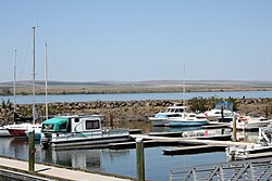
 Marina and Columbia River in Irrigon | |
 Location in Oregon | |
| Coordinates: 45°53′44″N 119°29′34″W / 45.89556°N 119.49278°W | |
| Country | United States |
| State | Oregon |
| County | Morrow |
| Incorporated | February 28, 1957 |
| Government | |
| • Mayor | Daren Strong[1] |
| Area | |
| • Total | 1.45 sq mi (3.75 km2) |
| • Land | 1.30 sq mi (3.36 km2) |
| • Water | 0.15 sq mi (0.39 km2) |
| Elevation | 302 ft (92 m) |
| Population | |
| • Total | 2,011 |
| • Density | 1,550.50/sq mi (598.83/km2) |
| Time zone | UTC-8 (Pacific) |
| • Summer (DST) | UTC-7 (Pacific) |
| ZIP code | 97844 |
| Area code | 541 |
| FIPS code | 41-36500[5] |
| GNIS feature ID | 2410115[3] |
| Website | City of Irrigon |
Irrigon is a city in Morrow County, Oregon, United States, on the Columbia River and U.S. Route 730. The city is part of the Pendleton–Hermiston Micropolitan Statistical Area. The population was 1,826 at the 2010 census.
Irrigon was incorporated on February 28, 1957. The Umatilla Chemical Depot and the Umatilla Chemical Agent Disposal Facility are about 4 miles (6 km) south of the city near the intersection of Interstate 84 (I-84) and Interstate 82 (I-82). The Irrigon Hatchery is along the Columbia River about 3 miles (5 km) west of Irrigon.[6]
- ^ "Irrigon City Council". City of Irrigon. Retrieved December 31, 2014.
- ^ "ArcGIS REST Services Directory". United States Census Bureau. Retrieved October 12, 2022.
- ^ a b U.S. Geological Survey Geographic Names Information System: Irrigon, Oregon
- ^ Cite error: The named reference
USCensusDecennial2020CenPopScriptOnlywas invoked but never defined (see the help page). - ^ Cite error: The named reference
wwwcensusgovwas invoked but never defined (see the help page). - ^ "Irrigon Hatchery: Operations Plan 2013" (PDF). Oregon Department of Fish and Wildlife. Archived from the original (PDF) on January 29, 2017. Retrieved July 16, 2013.