Irvington | |
|---|---|
neighborhood statistical area | |
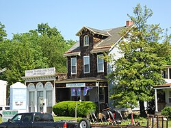
 Storefront view along Frederick Avenue in the Baltimore neighborhood of Irvington | |
| Coordinates: 39°16′53″N 76°41′03″W / 39.281434°N 76.684141°W | |
| Country | United States |
| State | Maryland |
| City | Baltimore |
| Area | |
| • Total | 0.884 sq mi (2.29 km2) |
| • Land | 0.884 sq mi (2.29 km2) |
| [1] | |
| Population | |
| • Estimate (2022) | 5,402 |
| [1] | |
| Time zone | UTC-5 (Eastern) |
| • Summer (DST) | UTC-4 (EDT) |
| ZIP code | 21229 |
| Area code | 410, 443, and 667 |
Irvington is a neighborhood in the Southwest District of Baltimore, located between Yale Heights neighborhood to the west and the Gwynns Falls neighborhood to the east. It was historically nicknamed "Skulltown" for its three large cemeteries: Loudon Park, Mount Olivet and New Cathedral.[2]
More than 50 percent of the homes in Irvington were built before 1950. Its population in 2022 was estimated at 5,402.[1]
The community's boundary with the Gwynns Falls neighborhood is drawn by Caton Avenue and the MARC Penn Line. Its boundary with Yale Heights follows Maiden Choice Run from Frederick Avenue (north) to Loudon Park Cemetery (south). Irvington's southwest corner encompasses Loudon Park Cemetery, ending at Beechfield Avenue (west), where it meets the Beechfield neighborhood and Wilkens Avenue (south).[1]
- ^ a b c d Irvington neighborhood in Baltimore, Maryland. City-Data.com. Retrieved 2024-09-27
- ^ D'Arcy, Janet (May 18, 1997). "Everything for Building a Life". The Baltimore Sun.
