| Isabella Dam | |
|---|---|
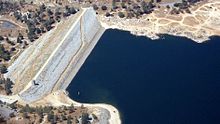
 Aerial view | |
| Location | Kern County, California |
| Coordinates | 35°38′46″N 118°28′56″W / 35.64611°N 118.48222°W |
| Construction began | 1948 |
| Opening date | 1953 |
| Operator(s) | |
| Dam and spillways | |
| Impounds | Lower Kern River |
| Height | 185 ft (56 m) |
| Length | 1,695 ft (517 m) |
| Spillways | Ungated concrete overflow |
| Spillway capacity | 49,000 cu ft/s (1,400 m3/s) |
| Reservoir | |
| Creates | Lake Isabella |
| Total capacity | 568,000 acre⋅ft (0.701 km3) |
| Catchment area | 2,074 sq mi (5,370 km2) |
| Surface area | 11,000 acres (4,500 ha) |
| Power Station | |
| Installed capacity | 12 MW |
| Annual generation | 22,610,000 KWh (2001–2012)[1] |
Isabella Dam is an embankment dam located in the Kern River Valley, about halfway down the Kern River course, between the towns of Kernville and Lake Isabella in Kern County, California.
Isabella Dam serves agricultural, hydroelectric, and flood control uses.[2] Lake Isabella (the reservoir created by the dam) also serves as a recreational and tourist attraction. Water sports, fishing, boating, camping, and hiking are common throughout the area, as well as the Sequoia National Forest.
- ^ "California Hydroelectric Statistics & Data". California Energy Commission. Archived from the original on 2018-02-26. Retrieved 2018-04-26.
- ^ Lakes Online – Lake Isabella Dam Information