| Ishi Wilderness | |
|---|---|
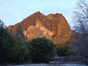
 Black Rock with Mill Creek in foreground | |
Map of the state of California | |
| Location | Tehama County, California, Sierra/Cascade region |
| Nearest city | Red Bluff |
| Coordinates | 40°08′05″N 121°45′19″W / 40.13472°N 121.75528°W |
| Area | 41,339 acres (167.29 km2) |
| Established | 1984 |
| Governing body | U.S. Forest Service and Bureau of Land Management |
The Ishi Wilderness is a 41,339 acre (167 km2)[1] wilderness area located on the Lassen National Forest in the Shasta Cascade foothills of northern California, United States. The Ishi Wilderness is located approximately 20 miles (32 km) east of Red Bluff. The wilderness was created when the US Congress passed the California Wilderness Act of 1984. The land is etched by wind and water, and dotted with basalt outcroppings, caves, and unusual pillar lava formations. The land is a series of east-west running ridges framing rugged river canyons, with the highest ridges attaining elevations of 4,000 feet (1,200 m). Deer Creek and Mill Creek are the principal drainages and flow into the Sacramento River.
The Ishi Wilderness is the only protected area in California that preserves a significant portion of the Sierra/Cascade foothill region of the southernmost Cascade Ranges.[2]
Almost the entire wilderness area was burned down by the Park Fire in mid-2024, causing it to currently lack significant greenery.
- ^ Wilderness.net data page accessed Dec.25, 2008
- ^ Adkinson, Ron p.185

