This article needs additional citations for verification. (June 2014) |
 View of a part of Tierra del Fuego | |
| Geography | |
|---|---|
| Location | Tierra del Fuego |
| Coordinates | 54°S 69°W / 54°S 69°W |
| Archipelago | Tierra del Fuego |
| Area | 47,992 km2 (18,530 sq mi) |
| Area rank | 29th |
| Highest elevation | 2,580 m (8460 ft) |
| Highest point | Monte Shipton |
| Administration | |
| Province | |
| Largest settlement | Ushuaia (pop. 74,752) |
| Region | |
| Largest settlement | Porvenir (pop. 4,807) |
| Demographics | |
| Population | 133,902 |
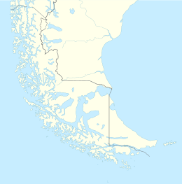
Isla Grande de Tierra del Fuego (English: Big Island of the Land of Fire) also formerly Isla de Xátiva[1] is an island near the southern tip of South America from which it is separated by the Strait of Magellan. The western portion (61.4%) of the island (29,484.7 km2 (11,384.1 sq mi)) is in Chile (Province of Tierra del Fuego and Antártica Chilena Province), while the eastern portion (38.6%, 18,507.3 km2 (7,145.7 sq mi)) is in Argentina (Tierra del Fuego Province). It forms the major landmass in an extended group of islands or archipelago also known as Tierra del Fuego.
The island has an area of 47,992 km2 (18,530 sq mi), making it the largest island in South America and the 29th largest island in the world. Its two biggest towns are Ushuaia and Río Grande, both in Argentina. Other towns are Tolhuin, Porvenir, Camerón, and Cerro Sombrero. The Argentine side, Tierra del Fuego Province, has 127,205 inhabitants (2010), whereas the Chilean side has only 6,656 (2012), almost all located in the Tierra del Fuego Province.
Its highest point is unofficially named Monte Shipton (2,580 m (8,465 ft)), in Chile. Nearby Mount Darwin was previously thought to be the tallest mountain on the island, but is just less than a hundred metres shorter.[2] The northern parts of the island have oil deposits; Cerro Sombrero in Chile is the main extraction centre in the island.
On 17 December 1949, an earthquake occurred in the Chilean portion, near the Argentine border. Recorded as 7.8 on the moment magnitude scale, it was the most powerful ever recorded in the south of Argentina.[3]
- ^ Tierra de Fuego, antes «Isla de Xativa» Cercle Català d'Història, www.cch.cat, accessed 5 February 2021
- ^ John Shipton (2004). "Monte Shipton or Monte Darwin?" (PDF). Alpine Journal. London: Alpine Club: 132–142. Retrieved March 28, 2012.
- ^ (in Spanish) Instituto Nacional de Prevención Sísmica. Listado de Terremotos Históricos Archived 2011-09-29 at the Wayback Machine.gistering
