Isla de Pascua
Rapa Nui | |
|---|---|
 | |
| Coordinates: 27°7′S 109°22′W / 27.117°S 109.367°W | |
| Country | Chile |
| Region | Valparaíso |
| Province | Isla de Pascua |
| Created | February 22, 1966 |
| Seat | Hanga Roa |
| Government | |
| • Type | Municipality |
| • Body | Municipal council |
| • Alcalde | Pedro Edmunds Paoa (PRO) |
| Area | |
| • Total | 163.6 km2 (63.2 sq mi) |
| Highest elevation | 507 m (1,663 ft) |
| Lowest elevation | 0 m (0 ft) |
| Population (2017 census) | |
| • Total | 7,750[1] |
| Time zone | UTC−6 (CLT) |
| • Summer (DST) | UTC−5 (CLST) |
| Country Code | +56 |
| Currency | Peso (CLP) |
| Language | Spanish, Rapa Nui |
| Driving side | right |
| Website | http://www.municipalidaddeisladepascua.cl |
| NGA UFI=-905269 | |
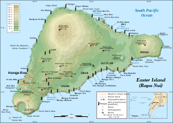
Isla de Pascua (Easter Island; Rapa Nui) is a Chilean commune with a special regime,[note 1] located within Isla de Pascua Province in Valparaíso Region. It is the only commune in Isla de Pascua Province, comprising Easter Island and Isla Salas y Gómez. Its capital is Hanga Roa, located in the southwestern area of the main island, where most of the local population resides.
- ^ "Censo 2017". National Statistics Institute (in Spanish). Archived from the original on 11 May 2018. Retrieved 11 May 2018.
- ^ Constitución Política de la República de Chile. Artículo 126 bis. Retrieved 18 June 2020.
{{cite book}}: CS1 maint: location (link) - ^ a b "Censo de Población y Vivienda 2002". National Statistics Institute. Archived from the original on 15 July 2010. Retrieved 1 May 2010.
Cite error: There are <ref group=note> tags on this page, but the references will not show without a {{reflist|group=note}} template (see the help page).


