Islamorada, Florida | |
|---|---|
| Village of Islamorada | |
 One of a few beaches on the Atlantic side of Islamorada | |
| Motto: "Village of Islands" | |
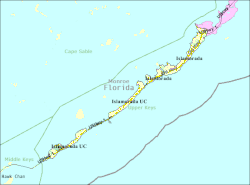
 Location of Islamorada, Florida | |
 U.S. Census Bureau map showing village boundaries | |
| Coordinates: 24°56′9″N 80°36′49″W / 24.93583°N 80.61361°W | |
| Country | |
| State | |
| County | Monroe |
| Incorporated | December 31, 1997 |
| Government | |
| • Type | Council–Manager |
| • Mayor | Joseph "Buddy" Pinder III |
| • Vice Mayor | Sharon Mahoney |
| • Council Members | Mark Gregg, Elizabeth Jolin, and Henry Rosenthal |
| • Village Manager | Ed Koconis |
| • Village Clerk | Marne McGrath |
| Area | |
• Total | 6.70 sq mi (17.35 km2) |
| • Land | 6.45 sq mi (16.70 km2) |
| • Water | 0.25 sq mi (0.65 km2) |
| Population | |
• Total | 7,107 |
| • Density | 1,102.03/sq mi (425.48/km2) |
| Time zone | UTC-5 (Eastern (EST)) |
| • Summer (DST) | UTC-4 (EDT) |
| ZIP codes | 33036, 33070 |
| Area code | 305 |
| FIPS code | 12-34132[3] |
| Website | www |
Islamorada (also sometimes Isla Morada) is an incorporated village in Monroe County, Florida, United States. It is located directly between Miami and Key West on five islands—Tea Table Key, Lower Matecumbe Key, Upper Matecumbe Key, Windley Key and Plantation Key—in the Florida Keys. As of the 2020 census, the village had a population of 7,107,[2] up from 6,119 in 2010.[4]
- ^ "2022 U.S. Gazetteer Files: Florida". United States Census Bureau. Retrieved January 18, 2023.
- ^ a b "P1. Race – Islamorada, Village of Islands village, Florida: 2020 DEC Redistricting Data (PL 94-171)". U.S. Census Bureau. Retrieved January 18, 2023.
- ^ "U.S. Census website". United States Census Bureau. Retrieved January 31, 2008.
- ^ "P1. Race – Islamorada, Village of Islands village, Florida: 2010 DEC Redistricting Data (PL 94-171)". U.S. Census Bureau. Retrieved January 18, 2023.