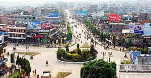
Itahari
ईटहरी | |
|---|---|
 Itahari | |
| Motto(s): "Clean, Green and Commercial City". | |
 Map of Itahari | |
Location of Itahari in Koshi Province | |
| Coordinates: 26°39′47″N 87°16′28″E / 26.66306°N 87.27444°E | |
| Country | |
| Province | Koshi |
| District | Sunsari |
| Wards | 20 |
| Settled | - |
| Government | |
| • Type | Mayor-council |
| • Mayor | Hem Karna Paudel (Congress) |
| • Deputy Mayor | Sangita Kumari Chaudhary(UML) |
| Area | |
• Total | 36.21 sq mi (93.78 km2) |
| Population (2021) | |
• Total | 198,098 |
| • Rank | 9th (Nepal) 2nd (Province No. 1) |
| • Density | 5,500/sq mi (2,100/km2) |
| • Ethnicities | Bahun Chhetri Tamang Limbu Rai Tharu Magars Newars |
| Languages | |
| • Official | Nepali |
| Time zone | UTC+5:45 (NST) |
| Postal Code | 56705 |
| Area code | 025 |
| Climate | Cwa |
| Website | itaharimun |

Itahari (Nepali: ईटहरी) is a sub-metropolitan city in the Sunsari District of Koshi Province in Nepal. Itahari city has grown as an important business hub of eastern Nepal. It is the second most populous city in eastern Nepal after Biratnagar. Situated 25 kilometres north of the provincial capital of Biratnagar, 16 kilometres south of Dharan and 92 kilometres west of Kakarbhitta, Itahari serves as a junction point of the east-west Mahendra Highway and the north–south Koshi Highway. Itahari has an estimated city population of 198,098 living in 40,207 households as per 2021 Nepal census. It is one of the fastest-growing cities in Eastern Nepal. It is one of the cities of the Greater Birat Development Area which incorporates the cities of Biratnagar-Itahari-Gothgau-Biratchowk-Dharan[1] primarily located on the Koshi Highway in Eastern Nepal, with an estimated total urban agglomerated population of 804,300 people living in 159,332 households.[2]
According to the Ministry of Federal Affairs and Local Development, Itahari has an area of 93.78 square kilometres (36.21 sq mi) with 140,517 people living in 33,794 individual households as of Census of Nepal 2011.[3][4][5][6] The town is divided into a total of 20 wards.[3] The municipality was established in 1997 and became a sub-metro in 2014.
- ^ "Capital of Province 1 to be scattered in various districts - myRepublica - the New York Times Partner, Latest news of Nepal in English, Latest News Articles". myrepublica.nagariknetwork.com. Archived from the original on 13 May 2021. Retrieved 14 March 2022.
- ^ "Census Nepal 2021". censusnepal.cbs.gov.np. Archived from the original on 27 January 2022. Retrieved 22 February 2022.
- ^ a b "स्थानीय तहहरुको विवरण". www.mofald.gov.np/en. MoFALD. Archived from the original on 31 August 2018. Retrieved 16 April 2018.
- ^ "CITY POPULATION – statistics, maps & charts". www.citypopulation.de. 8 October 2017. Archived from the original on 16 April 2018. Retrieved 16 April 2018.
- ^ "Itahari Sub-Metropolitan City Office (Government of Nepal)". itaharimun.gov.np. 14 January 2018. Archived from the original on 15 January 2018. Retrieved 14 January 2018.
- ^ "Itahari Sub Metropolitan City". nepaloutlook.com. 14 January 2018. Archived from the original on 15 January 2018. Retrieved 14 January 2018.

