Itaporanga d'Ajuda | |
|---|---|
municipality | |
| Municipio de Itaporanga d'Ajuda | |
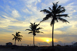
 Praia da Caueira, Itaporanga d'Ajuda | |
 Location of Itaporanga d'Ajuda in the State of Sergipe | |
| Coordinates: 10°59′52″S 37°18′39″W / 10.99778°S 37.31083°W | |
| Country | Brazil |
| Region | Northeast Region |
| State | |
| Area | |
| • Total | 757 km2 (292 sq mi) |
| Population | |
| • Total | 34,709 |
| • Density | 46/km2 (120/sq mi) |
| Time zone | UTC−3 (BRT) |
Itaporanga d'Ajuda is a Brazilian municipality in the Northeastern state of Sergipe. It covers 757 square kilometres (292 sq mi), has a population of 34,709 (2020) and a population density of 46 residents per km2 (120/sq mi).[1] It is home to the Tejupeba House and the Chapel of the Colégio Sugar Plantation, a plantation house and chapel cited as the first Jesuits settlement in Portuguese Brazil.
The municipality contains part of the Serra de Itabaiana National Park.[2]
- ^ Cite error: The named reference
iwas invoked but never defined (see the help page). - ^ Unidade de Conservação: Parque Nacional da Serra de Itabaiana (in Portuguese), MMA: Ministério do Meio Ambiente, retrieved 2016-05-03


