| Ivinghoe Beacon | |
|---|---|
Ivinghoe Beacon, looking north from the Ridgeway | |
| Highest point | |
| Elevation | 233 m (764 ft) |
| Coordinates | 51°50′31″N 0°36′21″W / 51.841985°N 0.605755°W |
| Geography | |
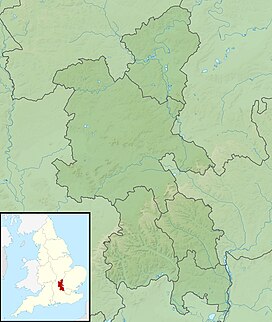
Ivinghoe Beacon shown within Buckinghamshire | |
| Location | Ivinghoe |
| Parent range | Chiltern Hills |
| OS grid | SP961168 |
Ivinghoe Beacon is a prominent hill and landmark in Buckinghamshire, England, 233 m (757 ft) above sea level[1] in the Chiltern Hills, close to Ivinghoe and Aldbury. Dunstable, Berkhamsted and Tring are nearby.
The Beacon lies within the Ashridge Estate and is managed and owned by the National Trust.[2][3] It is the starting point of the Icknield Way to the east, and the Ridgeway long-distance path to the west.

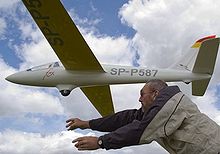
Ivinghoe Beacon is a popular spot for walkers and sightseers. Model aircraft enthusiasts also use lift generated by the wind blowing up the hill to fly their unpowered aircraft – a technique known as slope soaring.[4]
- ^ "OS-Net | Ordnance Survey".
- ^ "Ivinghoe Beacon at Ashridge Estate". National Trust. Retrieved 23 July 2019.
- ^ "Map categories: Ivinghoe Beacon". www.chilternsaonb.org. The Chilterns AONB. Retrieved 23 July 2019.
- ^ Those wishing to participate in model flying at the Beacon should review and comply with the agreement between the National Trust and the Ivinghoe Soaring Association.
