Ivins, Utah | |
|---|---|
 Looking north along South 200 West in Ivins, May 2013 | |
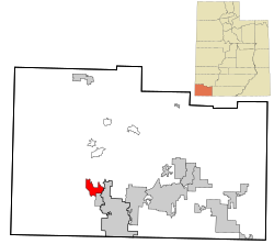
 Location in Washington County and the state of Utah | |
| Coordinates: 37°10′3″N 113°40′51″W / 37.16750°N 113.68083°W | |
| Country | United States |
| State | Utah |
| County | Washington |
| Incorporated | 1935 |
| Became a city | January 1, 1998 |
| Named for | Anthony W. Ivins |
| Area | |
| • Total | 9.48 sq mi (24.56 km2) |
| • Land | 9.43 sq mi (24.43 km2) |
| • Water | 0.05 sq mi (0.13 km2) |
| Elevation | 3,100 ft (900 m) |
| Population (2021)[3] | |
| • Total | 9,532 |
| • Density | 1,010.8/sq mi (392.3/km2) |
| Time zone | UTC-7 (Mountain (MST)) |
| • Summer (DST) | UTC-6 (MDT) |
| ZIP code | 84738 |
| Area code | 435 |
| FIPS code | 49-38710[4] |
| GNIS feature ID | 1429067[2] |
| Website | www.ivins.com |
Ivins (/ˈaɪvɪnz/ EYE-vinz) is a city in southwestern Washington County, Utah, United States. It is a part of the St. George Metropolitan Area as a suburb or "bedroom" community. The population was 8,978 at the 2020 census, up from 6,753 at the 2010 census.[5] Although Ivins was listed as a town in the 2000 census,[4] it became a city in 1998.
- ^ "2019 U.S. Gazetteer Files". United States Census Bureau. Retrieved August 7, 2020.
- ^ a b U.S. Geological Survey Geographic Names Information System: Ivins, Utah
- ^ "Ivins City, Utah". Census.gov. 2022. Retrieved June 19, 2023.
- ^ a b "U.S. Census website". United States Census Bureau. Retrieved January 31, 2008.
- ^ "U.S. Census Bureau QuickFacts: Ivins city, Utah". Retrieved August 7, 2023.