Ivry-sur-le-Lac | |
|---|---|
 | |
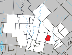
 Location within Les Laurentides RCM | |
| Coordinates: 46°04′N 74°21′W / 46.07°N 74.35°W[1] | |
| Country | |
| Province | |
| Region | Laurentides |
| RCM | Les Laurentides |
| Settled | 1852 |
| Constituted | January 1, 2006 |
| Government | |
| • Mayor | André Ibghy |
| • Federal riding | Laurentides—Labelle |
| • Prov. riding | Bertrand |
| Area | |
| • Total | 34.70 km2 (13.40 sq mi) |
| • Land | 29.67 km2 (11.46 sq mi) |
| Population (2016)[3] | |
| • Total | 387 |
| • Density | 13/km2 (30/sq mi) |
| • Pop 2011-2016 | |
| • Dwellings | 421 |
| Time zone | UTC−5 (EST) |
| • Summer (DST) | UTC−4 (EDT) |
| Postal code(s) | |
| Area code | 819 |
| Highways | |
| Website | www |
Ivry-sur-le-Lac (French pronunciation: [ivʁi syʁ lə lak], literally Ivry on the Lake) is a village and municipality in the Laurentides region of Quebec, Canada, part of the Les Laurentides Regional County Municipality. The municipality completely encompasses Lake Manitou which is a popular cottage vacation location.
The village of Ivry-sur-le-Lac is located at the head of the north-east bay (Lacasse Bay), and the hamlet of Lac-Manitou-Sud is at the head of the south-east bay of Lake Manitou.[4]
- ^ Cite error: The named reference
toponymiewas invoked but never defined (see the help page). - ^ a b Cite error: The named reference
mamrotwas invoked but never defined (see the help page). - ^ a b Cite error: The named reference
cp2016was invoked but never defined (see the help page). - ^ "Lac-Manitou-Sud" (in French). Commission de toponymie du Québec. Retrieved 2009-03-27.
