Ixtapaluca | |
|---|---|
Town & Municipality | |
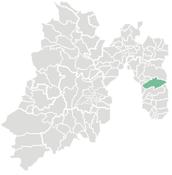
 Location of Ixtapaluca in the State of Mexico | |
| Coordinates: 19°19′07″N 98°52′56″W / 19.31861°N 98.88222°W | |
| Country | |
| State | |
| Region | Ixtapaluca |
| Metro area | Greater Mexico City |
| Municipal Status | December 5, 1820[1] |
| Municipal Seat | Ixtapaluca |
| Government | |
| • Type | Ayuntamiento |
| • Municipal President | Carlos Enriquez Santos |
| Area | |
• Municipality | 327.40 km2 (126.41 sq mi) |
| • Land | 327.40 km2 (126.41 sq mi) |
| • Water | 0.00 km2 (0.00 sq mi) |
| Elevation (seat) | 2,250 m (7,380 ft) |
| Population (2015) | |
• Municipality | 495,563 |
| • Seat | 290,076 |
| Demonym | Ixtapaluquense |
| Time zone | UTC-6 (CST) |
| Postal code (of seat) | 56530 |
| Area code | 55 |
| Website | Official website (in Spanish) |
Ixtapaluca is a city and a municipality in the eastern part of the State of Mexico in Mexico. It lies between Mexico City and the western border of the state of Puebla. The name Ixtapaluca means "Where the salt gets wet".[2]
As of 2006, Ixta included part of the world's largest mega-slum, along with Chalco and Neza.[3]
- ^ "Bando Municipal de Ixtapaluca 2015" (PDF). H. Ayuntamiento de Ixtapaluca 2013-2015. Retrieved September 7, 2015.[permanent dead link]
- ^ "Enciclopedia de los Municipios de Mexico Estado de Mexico Huixquilucan". Archived from the original on 2007-09-27. Retrieved 2008-03-08.
- ^ Mike Davis, Planet of Slums, La Découverte, Paris, 2006 (ISBN 978-2-7071-4915-2), p. 31.