| Jackson Saltwater River Western Branch, Gisborne Creek, Macedon River, Saltwater River, Saltwater Creek[1] | |
|---|---|
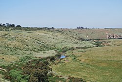
 The narrow valley cut by Jackson Creek near Clarkefield | |
 Contour map of the Maribyrnong River basin; Jackson Creek rises midpoint between the 400–500-metre (1,300–1,600 ft) contour line. | |
| Etymology | After early Colonial settlers, 'Hungry' William Jackson[2] |
| Location | |
| Country | Australia |
| State | Victoria |
| Region | Victorian Midlands (IBRA), Greater Melbourne |
| Local government area | Macedon Ranges Shire |
| Suburbs | Gisborne, Sunbury |
| Physical characteristics | |
| Source | Macedon Ranges, Great Dividing Range |
| Source confluence | Distill, Gisborne and Slaty creeks |
| • location | within Rosslynne Reservoir, northwest of Gisborne |
| • coordinates | 37°28′9″S 144°34′4″E / 37.46917°S 144.56778°E |
| • elevation | 459 m (1,506 ft) |
| Mouth | confluence with the Deep Creek to form the Maribyrnong River |
• location | west of Melbourne Airport |
• coordinates | 37°40′10″S 144°48′16″E / 37.66944°S 144.80444°E |
• elevation | 42 m (138 ft) |
| Length | 71 km (44 mi) |
| Basin features | |
| River system | Port Phillip catchment |
| Tributaries | |
| • left | Riddells Creek |
| • right | Longview Creek |
| National park | Organ Pipes NP |
| [3] | |
The Jackson Creek (sometimes referred to as Jacksons Creek[1]) is a watercourse within the Port Phillip catchment, located in the outer northern suburbs of Melbourne, in the Australian state of Victoria.
- ^ a b "Jackson Creek: 18034". VICNAMES. Government of Victoria. Archived from the original on 16 April 2014. Retrieved 15 April 2014.
- ^ "Jackson Creek: 18034: Historical information". VICNAMES. Government of Victoria. 10 May 2012. Archived from the original on 16 April 2014. Retrieved 15 April 2014.
- ^ "Map of Jackson Creek, VIC". Bonzle Digital Atlas of Australia. Retrieved 15 April 2014.