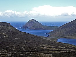
 Jacquemart Island in the distance | |
| Geography | |
|---|---|
| Coordinates | 52°37′10″S 169°07′33″E / 52.61944°S 169.12583°E |
| Archipelago | Campbell Island group |
| Area | 19 ha (47 acres) |
| Length | 0.75 km (0.466 mi) |
| Width | 0.5 km (0.31 mi) |
| Highest elevation | 229 m (751 ft)[1] |
| Administration | |
New Zealand | |
| Demographics | |
| Population | Uninhabited |
Jacquemart Island, one of the islets surrounding Campbell Island in New Zealand, lies 1 km (1⁄2 nmi) south of Campbell Island and is the southernmost island of New Zealand.
The name commemorates Captain J. Jacquemart, of the vessel FRWS Vire, that supported the French 1874 Transit of Venus Expedition to Campbell Island.[2]
52°37′10″S 169°07′33″E / 52.61944°S 169.12583°E
- ^ "Campbell Island Bicentennial Expedition". 50° South Trust. 26 February 2014. Retrieved 17 October 2017.
- ^ Tobin, William. "The French Expedition to Campbell Island in 1874". Transit of Venus website. Archived from the original on 25 May 2010.
Adapted from I.S. Kerr -"Campbell Island: A History" (A.H. & A.W. Reed, Wellington, 1976)
