Jaggayyapeta | |
|---|---|
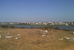
 Jaggayyapeta town from the Buddhist stupa site | |
| Nickname: Dongala bethavolu | |
 Interactive map | |
| Coordinates: 16°53′31″N 80°05′51″E / 16.8920°N 80.0976°E | |
| Country | |
| State | Andhra Pradesh |
| Region | Coastal Andhra |
| District | NTR |
| Government | |
| • Body | Jaggayyapet Municipality |
| • Member of Legislative Assembly | Sriram Rajagopal(Tatayya) |
| • Member of Parliament | Kesineni Srinivas (Nani) |
| Area | |
• Total | 60 km2 (20 sq mi) |
| • Rank | 2nd in district |
| Elevation | 55 m (180 ft) |
| Population (2011)[3] | |
• Total | 53,530 |
| • Density | 890/km2 (2,300/sq mi) |
| Languages | |
| • Officials | Telugu |
| Time zone | UTC+5:30 (IST) |
| PIN | 521 175 |
| Telephone code | +91–8654 |
| Vehicle registration | AP–16, AP-39, AP-40 |
| Lok Sabha constituency | Vijayawada |
| Vidhan Sabha constituency | Jaggayyapet |
Jaggayyapeta, also spelled “Jaggaiahpet”, is a census town in NTR district of the Indian state of Andhra Pradesh, located just southwest of the border with Telangana. It is also the mandal headquarters of Jaggayyapeta mandal of Nandigama revenue division.[4][5] Jaggayyapet is the second biggest town in the district followed by Vijayawada.The town is located on the banks of the Paleru River which is a tributary of the Krishna River.
- ^ "District Census Handbook - Krishna" (PDF). Census of India. p. 16,48. Retrieved 29 January 2016.
- ^ "Elevation for Jaggayyapet". Veloroutes. Retrieved 12 August 2014.
- ^ "Census 2011". The Registrar General & Census Commissioner, India. Retrieved 25 July 2014.
- ^ "Krishna District Mandals" (PDF). Census of India. pp. 474, 523. Retrieved 21 January 2015.
- ^ "Administrative Setup". Krishna District Official Website. National Informatics Centre. Archived from the original on 20 October 2014. Retrieved 9 February 2015.

