This article needs additional citations for verification. (August 2020) |
Jaghori
جاغوری | |
|---|---|
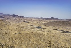
 View of Sang-e-Masha (Central Jaghori) from Badasiya Mountain, | |
| Motto: Persian: جاغوری سرزمین آرزوها | |
| Coordinates: 33°7′59″N 67°27′13″E / 33.13306°N 67.45361°E | |
| Country | Afghanistan |
| Province | Ghazni |
| Capital | Sang-e-Masha |
| Area | |
| • Total | 3,000 km2 (1,000 sq mi) |
| • Water | 0 km2 (0 sq mi) |
| Population (2015)[1] | |
| • Total | 650,000 |
| • Density | 220/km2 (560/sq mi) |
| Time zone | + 4.30 |
Preview warning: Page using Template:Infobox settlement with unknown parameter "highest_elevation_m"
Jaghori (Persian: جاغوری) is one of the main districts of the Ghazni province in Afghanistan. It is located in the highlands in the southern fringes of the Hazaristan region. It occupies 1,855 km2. in the upper Arghandab valley.[3] The population is estimated to be around 560,000 in 2015.[4] The district capital, Sange-e-Masha, is where major business transactions take place. The district is heavily dependent on agriculture, and migrant workers as the main sources of income. Other major marketplaces are in Ghojor and Anguri.
Climate of Jaghori is generally arid continental, with cold and snowy winters, and hot summers with temperatures rising between 25 °C to 38 °C.
- ^ "Estimated Population of Afghanistan 2019-20" (PDF). Central Statistics Organization. 18 November 2019. p. 21. Archived from the original (PDF) on 9 June 2020. Retrieved 21 August 2020.
- ^ Arc - GIS - earth topographic nap - https://www.arcgis.com/home/webmap/viewer.html
- ^ Monsutti, Alessandro (2005), War and Migration: Social Networks and Economic Strategies of the Hazaras of Afghanistan, Routledge, pp. 69–, ISBN 978-1-135-48676-1
- ^ Cite error: The named reference
:0was invoked but never defined (see the help page).
