This article needs additional citations for verification. (July 2013) |
Jalpaiguri | |
|---|---|
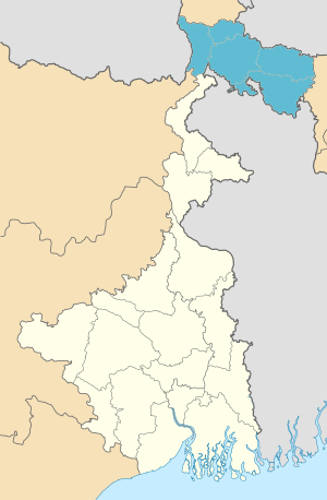
 Location of Jalpaiguri division in West Bengal | |
| Coordinates: 26°41′N 88°45′E / 26.683°N 88.750°E | |
| Country | India |
| State | West Bengal |
| Headquarters | Jalpaiguri |
| Government | |
| • Districts | Alipurduar, Cooch Behar, Darjeeling, Jalpaiguri, Kalimpong |
| Area | |
• Total | 12,713 km2 (4,909 sq mi) |
| Population (2011) | |
• Total | 8,538,755 |
| • Density | 670/km2 (1,700/sq mi) |
| Languages | |
| • Official | Bengali[1][2] |
| • Additional official | English[1] |
| Time zone | UTC+05:30 (IST) |
| Website | wb |
Jalpaiguri Division is one of the 5 divisions in the Indian state of West Bengal. It is the northernmost division of West Bengal. It is surrounded by Nepal on the western side, Bihar on South-Western side, Bhutan on the Northern side and Bangladesh on the southern side.[3]
- ^ a b "Fact and Figures". Wb.gov.in. Retrieved 5 July 2019.
- ^ "52nd Report of the Commissioner for Linguistic Minorities in India" (PDF). Nclm.nic.in. Ministry of Minority Affairs. p. 85. Archived from the original (PDF) on 25 May 2017. Retrieved 5 July 2019.
- ^ "Divisional Commissioners/ West Bengal". Office of the Resident Commissioner- Govt. of WB. 4 June 2019.