| James River | |
|---|---|
 James River at the crossing of the Blue Ridge Parkway | |
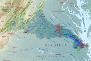
 A map of the James River drainage basin | |
| Etymology | King James VI and I |
| Native name | Powhatan (Powhatan) |
| Location | |
| Country | United States |
| State | Virginia |
| Physical characteristics | |
| Source | Confluence of Cowpasture River and Jackson River |
| • location | Iron Gate, Allegheny Mountains, Virginia |
| • coordinates | 37°47′4″N 79°46′33″W / 37.78444°N 79.77583°W[1] |
| Mouth | Hampton Roads |
• location | Chesapeake Bay, Virginia |
• coordinates | 36°56′30″N 76°26′37″W / 36.94167°N 76.44361°W[1] |
| Length | 348 mi (560 km) |
| Basin size | 10,432 sq mi (27,020 km2) |
| Discharge | |
| • average | 6,835 cu ft/s (193.5 m3/s)[2] |
| • minimum | 10 cu ft/s (0.28 m3/s) |
| • maximum | 313,000 cu ft/s (8,900 m3/s) |
| Basin features | |
| Tributaries | |
| • left | Chickahominy River |
| • right | Appomattox River |
 | |

The James River is a river in Virginia that begins in the Appalachian Mountains and flows from the confluence of the Cowpasture and Jackson Rivers in Botetourt County 348 miles (560 km)[3] to the Chesapeake Bay.[4] The river length extends to 444 miles (715 km) if the Jackson River is included, the longer of its two headwaters,[3] it is the longest river in Virginia. Jamestown and Williamsburg, Virginia's first colonial capitals, and Richmond, Virginia's current capital, lie on the James River.
- ^ a b "James River". Geographic Names Information System. United States Geological Survey, United States Department of the Interior.
- ^ USGS data, accessed February 14, 2011
- ^ a b U.S. Geological Survey. National Hydrography Dataset high-resolution flowline data. The National Map Archived March 29, 2012, at the Wayback Machine, accessed April 1, 2011
- ^ "James River | Virginia, Map, History, & Facts | Britannica". www.britannica.com. March 5, 2024. Retrieved April 5, 2024.