Jammerbugt Municipality
Jammerbugt Kommune (Danish) | |
|---|---|
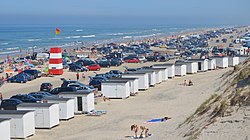
 Beach by Blokhus | |
 | |
| Coordinates: 57°08′N 9°34′E / 57.13°N 9.57°E | |
| Country | Denmark |
| Region | North Jutland |
| Established | 1 January 2007 |
| Seat | Aabybro |
| Government | |
| • Mayor | Mogens Christian Gade (V) |
| Area | |
| • Total | 866.25 km2 (334.46 sq mi) |
| Population (1. January 2024)[1] | |
| • Total | 38,234 |
| • Density | 44/km2 (110/sq mi) |
| Time zone | UTC1 (CET) |
| • Summer (DST) | UTC2 (CEST) |
| Municipal code | 849 |
| Website | www |
Jammerbugt Municipality (Danish: Jammerbugt Kommune) is a municipality (Danish: kommune) in the North Jutland Region on the North Jutlandic Island. It is located along the coast of Skagerrak to the north and the Limfjord to the south. It borders the municipalities of Thisted, Vesthimmerland, Aalborg, Brønderslev and Hjørring.
Jammerbugt Municipality was formed during the municipal reform of 2007, when the municipalities of Brovst Municipality, Fjerritslev Municipality, Pandrup Municipality and Aabybro Municipality were merged.
Since the municipality's foundation in 2007 the mayor has been Mogens Christian Gade of the Venstre party. Mogens Christian Gade was also the mayor of Brovst Municipality since 2002 and until it was dissolved in 2007.
The name of the region, the Jammerbugt, translating to the Bay of Woe, was originally given due to the numerous shipwrecks laid there.[2]
The municipality include the uninhabited islands of Fruensholm and Troldholme.
- ^ BY2: Population 1. January by municipalities The Mobile Statbank from Statistics Denmark
- ^ Murray, John (1871). A Handbook for Travellers in Denmark, Norway, and Sweden. London: John Murray. p. 96.
