| Jampui Hills | |
|---|---|
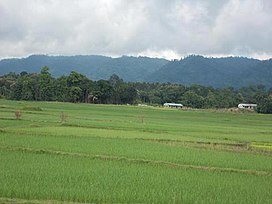
 View of the Jampui Hills in the East from the plains of Kanchanpur. | |
| Highest point | |
| Peak | Thaidawr |
| Elevation | 930 m (3,050 ft) |
| Coordinates | 23°57′57″N 92°16′38″E / 23.965916°N 92.277346°E |
| Naming | |
| Native name | Zampui Tlangdung (Tippera) |
| Geography | |
| Location | Tripura, India |
| Parent range | Lushai Hills |

Jampui Hills is a part of the Mizo hills (Lushai Hills) range located in the North Tripura district in the north eastern part of the Indian state of Tripura. The average altitude of the hill range is approximately 1000 metres above sea level.
