Jamshoro District
| |
|---|---|
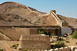
Top: Ranikot Fort Bottom: Buddhist Stupa at Naig Sharif | |
 Map of Pakistani Districts with Jamshoro District highlighted | |
| Coordinates: 25°25′57″N 68°15′47″E / 25.432512°N 68.263171°E | |
| Country | |
| Province | |
| Division | Hyderabad |
| Established | 14 December 2004 |
| Headquarters | Jamshoro |
| Government | |
| • Type | District Administration |
| • Deputy Commissioner | N/A |
| • District Police Officer | N/A |
| • District Health Officer | N/A |
| Area | |
| • Total | 11,260 km2 (4,350 sq mi) |
| Population | |
| • Total | 1,117,308 |
| • Density | 99/km2 (260/sq mi) |
| Time zone | UTC+5 (PST) |
| Number of Tehsils | 4 |
Jamshoro District (Sindhi: ضلعو ڄام شورو, Urdu: ضلع جامشورو), is a district of Sindh province, Pakistan. Jamshoro city is the capital while Kotri is the largest city of the Jamshoro District. The district borders Dadu district to the north. To the east, the Indus separates it from Shaheed Benazirabad, Matiari and Hyderabad districts. Thatta district lies to the south, and Karachi district to the south west. To the west, the Kheerthar Range separates it from the Sindh and Hub district of Baluchistan.
Jamshoro District was split from Dadu District in 14 December 2004[2] It is situated on the west bank of River Indus.
- ^ Cite error: The named reference
2023censuswas invoked but never defined (see the help page). - ^ "Four new districts created in Sindh". 2004. Retrieved 12 August 2021.
