Janesville | |
|---|---|
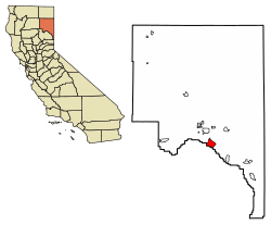
 Location of Janesville in Lassen County, California. | |
| Coordinates: 40°17′48″N 120°31′27″W / 40.29667°N 120.52417°W | |
| Country | |
| State | |
| County | Lassen County |
| Area | |
| • Total | 13.199 sq mi (34.186 km2) |
| • Land | 13.187 sq mi (34.154 km2) |
| • Water | 0.012 sq mi (0.032 km2) 0.09% |
| Elevation | 4,239 ft (1,292 m) |
| Population (2020) | |
| • Total | 2,461 |
| • Density | 190/sq mi (72/km2) |
| Time zone | UTC-8 (Pacific (PST)) |
| • Summer (DST) | UTC-7 (PDT) |
| ZIP Code | 96114 |
| Area code | 530 |
| GNIS feature IDs | 1658853; 2611437 |
| U.S. Geological Survey Geographic Names Information System: Janesville, California; U.S. Geological Survey Geographic Names Information System: Janesville, California | |
Janesville (also known as Lassen)[3] is a sparsely populated census-designated place[4] in Lassen County, California.[2] It is located 11 miles (18 km) southeast of Susanville,[3] at an elevation of 4239 feet (1292 m).[2] Janesville is located on the eastern slopes of the Sierra Nevada Mountain range. Its population is 2,461 as of the 2020 census, up from 1,408 from the 2010 census.
The community consists of an elementary school, a park, four churches, two gas stations, a pizza parlor, a coffee shop, a veterinary hospital, a hardware store, a post office, and a few other businesses.
Janesville stretches over a distance of 8 miles (13 km). Its ZIP Code is 96114. The community is inside area code 530.
- ^ "U.S. Census". Archived from the original on July 2, 2012.
- ^ a b c U.S. Geological Survey Geographic Names Information System: Janesville, California
- ^ a b Durham, David L. (1998). California's Geographic Names: A Gazetteer of Historic and Modern Names of the State. Clovis, Calif.: Word Dancer Press. p. 388. ISBN 1-884995-14-4.
- ^ U.S. Geological Survey Geographic Names Information System: Janesville, California
