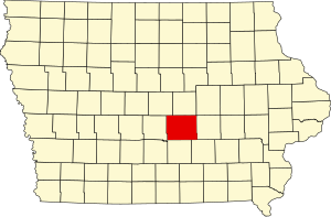
Jasper County | |
|---|---|
 Jasper County Courthouse in Newton | |
 Location within the U.S. state of Iowa | |
 Iowa's location within the U.S. | |
| Coordinates: 41°41′17″N 93°03′41″W / 41.688055555556°N 93.061388888889°W | |
| Country | |
| State | |
| Founded | 1846 |
| Named for | William Jasper |
| Seat | Newton |
| Largest city | Newton |
| Area | |
• Total | 733 sq mi (1,900 km2) |
| • Land | 730 sq mi (1,900 km2) |
| • Water | 2.5 sq mi (6 km2) 0.3% |
| Population (2020) | |
• Total | 37,813 |
| • Density | 52/sq mi (20/km2) |
| Time zone | UTC−6 (Central) |
| • Summer (DST) | UTC−5 (CDT) |
| Congressional district | 2nd |
| Website | www |
Jasper County is a county in the U.S. state of Iowa. As of the 2020 census, the population was 37,813.[1] The county seat is Newton.[2] The county was organized in 1846 and is named after Sergeant William Jasper, a Revolutionary War hero.[3]
Jasper County is part of the Des Moines–West Des Moines, IA Metropolitan Statistical Area.[4]
- ^ "2020 Census State Redistricting Data". census.gov. United states Census Bureau. Retrieved August 12, 2021.
- ^ "Find a County". National Association of Counties. Archived from the original on May 31, 2011. Retrieved June 7, 2011.
- ^ Weaver, James Baird (1912). Past and Present of Jasper County, Iowa, Volume 1. B.F. Bowen. p. 44.
- ^ United States Office of Management and Budget. "Update of Statistical Area Definitions and Guidance on Their Uses" (PDF). pp. 5, 36. Archived from the original (PDF) on May 14, 2006. Retrieved July 21, 2006.