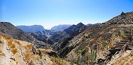
| Jebel Akhdar Mountains | |
|---|---|
 Terraces in Jebel Akhdar, 2011 | |
| Highest point | |
| Elevation | 3,018 m (9,902 ft)[1] |
| Coordinates | 23°06′N 57°24′E / 23.1°N 57.4°E |
| Naming | |
| Native name | Al-Jabal Al-Akhḍar (ٱلْجَبَل ٱلْأَخْضَر (Arabic)) |
| Geography | |
| Location | |
| Parent range | Al-Hajar Mountains |
The Jebel Akhdar Mountains (Arabic: ٱلْجَبَل ٱلْأَخْضَر, romanized: Al-Jabal Al-Akhḍar, lit. 'The Green Mountain') is a mountain range approximately 80 km (50 mi) long and 32 km (20 mi) wide,[2] that is part Hajar Mountains in Ad Dakhiliyah Governorate of Oman.
It rises to a height of 3,018 m (9,902 ft)[1][3] and encompasses the Saiq Plateau at 2,000 m (6,600 ft) above sea level.
Jebel Akhdar Mountains is famous for its labyrinth of wadis (river valleys) and terraced orchards, where pomegranates, apricots, and roses grow in abundance due to its mild Mediterranean climate.
The highest peak in the Jebel Akhdar Mountains is Jebel Shams,[4] which with its elevation of 3,018 m (9,902 ft) is also the highest peak in the Hajar range and in Oman.[1]
Jebel Shams also has a second summit (the South Summit), which is publicly accessible for trekking via the W4 Trail.[5] The elevation of the second south summit is 2,997 m (9,833 ft).[5]
- ^ a b c www.peakbagger.com - Jebel Shams, Oman
- ^ https://www.agda.ae/en/catalogue/tna/air/5/1284/n/39 Persian Gulf and Arabian Coast: mountains or mounds - Ref. AIR 5/1284 - PAGE 39 - The National Archives, London, England
- ^ "Mountains in Oman". Ministry of Tourism, Sultanate of Oman. Archived from the original on 2011-07-15. Retrieved 2018-12-19.
- ^ https://www.agda.ae/en/catalogue/tna/air/5/1284/n/55 Persian Gulf and Arabian Coast: mountains or mounds - Ref. AIR 5/1284 - PAGE 55 - The National Archives, London, England
- ^ a b "Trekking". website. Ministry of Tourism, Sultanate of Oman. Archived from the original on 2021-12-09. Retrieved 2014-01-08.


