Jefferson County | |
|---|---|
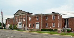
 The Jefferson County Courthouse in Hillsboro | |
 Location within the U.S. state of Missouri | |
 Missouri's location within the U.S. | |
| Coordinates: 38°16′N 90°32′W / 38.26°N 90.54°W | |
| Country | |
| State | |
| Founded | 1818 |
| Named for | Thomas Jefferson |
| Seat | Hillsboro |
| Largest city | Arnold |
| Area | |
• Total | 664 sq mi (1,720 km2) |
| • Land | 657 sq mi (1,700 km2) |
| • Water | 7.7 sq mi (20 km2) 1.2% |
| Population (2020) | |
• Total | 226,739 |
| Time zone | UTC−6 (Central) |
| • Summer (DST) | UTC−5 (CDT) |
| Congressional districts | 2nd, 3rd, 8th |
| Website | www |
Jefferson County is located in the eastern portion of the U.S. state of Missouri. It is a part of the St. Louis Metropolitan Area. As of the 2020 census, the population was 226,739,[1] making it the sixth-most populous county in Missouri. Its county seat is Hillsboro.[2] The county was organized in 1818 and named in honor of former president Thomas Jefferson.[3][4] In 1980, according to the U.S. census held that year, the county contained the mean center of U.S. population. Notably, this was the first census in which the center of population was west of the Mississippi River. Jefferson County is part of the St. Louis Metropolitan Statistical Area and encompasses many of the city's southern suburbs.
- ^ "Explore Census Data".
- ^ "Find a County". National Association of Counties. Archived from the original on May 31, 2011. Retrieved June 7, 2011.
- ^ Eaton, David Wolfe (1916). How Missouri Counties, Towns and Streams Were Named. The State Historical Society of Missouri. pp. 179.
- ^ Gannett, Henry (1905). The Origin of Certain Place Names in the United States. Govt. Print. Off. pp. 168.
