Jeffrey City, Wyoming | |
|---|---|
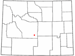
 Location of Jeffrey City, Wyoming | |
| Coordinates: 42°29′26″N 107°49′42″W / 42.49056°N 107.82833°W | |
| Country | United States |
| State | Wyoming |
| County | Fremont |
| Area | |
| • Total | 28.5 sq mi (73.8 km2) |
| • Land | 28.3 sq mi (73.4 km2) |
| • Water | 0.2 sq mi (0.4 km2) |
| Elevation | 6,335 ft (1,931 m) |
| Population | |
| • Total | 58 |
| • Density | 2.0/sq mi (0.79/km2) |
| Time zone | UTC−7 (Mountain (MST)) |
| • Summer (DST) | UTC−6 (MDT) |
| ZIP code | 82310 |
| Area code | 307 |
| FIPS code | 56-40555[2] |
| GNIS feature ID | 1590071[3] |

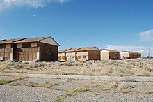
Jeffrey City is a former uranium mining boomtown located in Fremont County, in the central part of the U.S. state of Wyoming. The town is known in Wyoming and the American West as symbol of a boomtown that went "bust" very quickly, as the mine was shut down in 1982 and over 95% of the inhabitants left the town within three years.[4] The population was 58 at the 2010 census,[1] far lower than its onetime population of several thousand people. For statistical purposes, the United States Census Bureau has defined Jeffrey City as a census-designated place (CDP).
- ^ a b "Geographic Identifiers: 2010 Demographic Profile Data (G001): Jeffrey City CDP, Wyoming". U.S. Census Bureau, American Factfinder. Retrieved October 26, 2016.[dead link]
- ^ "U.S. Census website". United States Census Bureau. Retrieved January 31, 2008.
- ^ "US Board on Geographic Names". United States Geological Survey. October 25, 2007. Retrieved January 31, 2008.
- ^ Home on the Range No More: The Boom and Bust of a Wyoming Uranium Mining Town 1957 -1958.
