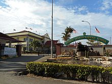
Jempol District | |
|---|---|
| Daerah Jempol | |
| Other transcription(s) | |
| • Jawi | جمڤول |
| • Chinese | 仁保县 |
| • Tamil | ஜெம்போல் |
 Location of Jempol District in Negeri Sembilan | |
 | |
Location of Jempol District in Malaysia | |
| Coordinates: 2°55′N 102°25′E / 2.917°N 102.417°E | |
| Country | |
| State | |
| Seat | Bandar Seri Jempol |
| Local area government(s) | Jempol Municipal Council |
| Government | |
| • District officer | Zazali Salehudin[1] |
| Area | |
• Total | 1,490.87 km2 (575.63 sq mi) |
| Population (2010)[3] | |
• Total | 112,354 |
| • Density | 75/km2 (200/sq mi) |
| Time zone | UTC+8 (MST) |
| • Summer (DST) | UTC+8 (Not observed) |
| Postcode | 72xxx |
| Calling code | +6-06 |
| Vehicle registration plates | N |
Jempol Municipal Council Majlis Perbandaran Jempol | |
|---|---|
 | |
| Type | |
| Type | |
| History | |
| Founded | 29 January 2019 |
| Preceded by | Jempol District Council |
| Leadership | |
President | Raja Norazli Raja Nordin |
| Meeting place | |
 | |
| 72120 Bandar Seri Jempol, Negeri Sembilan Darul Khusus | |
| Website | |
| www | |
Jempol | |
|---|---|
| Luak Jempol لواق جمڤول | |
 Luak of Jempol relative to other luaks in Negeri Sembilan | |
| Country | Malaysia |
| State | Negeri Sembilan |
| Adat institution | Yang di-Pertuan Besar of Negeri Sembilan |
| Government | |
| • Penghulu | Mazri Mansol |
The Jempol District (Negeri Sembilan Malay: Jompo; Jawi: جمڤول) is the largest district in the Malaysian state of Negeri Sembilan. The district borders Jelebu District to the northwest, Kuala Pilah District to the west, Tampin District to the south, Bera District, Pahang to the northeast and Segamat District, Johor to the east. Bandar Seri Jempol and Bahau are the principal towns in Jempol.[4]
Jempol is also the meeting point of Muar and Serting rivers. The meeting point had played an important transportation role in ancient times. Known historically as Jalan Penarikan, it connected trade posts west of the Malay Peninsula with population centres in the east coast and vice versa.
- ^ "Laman Web Rasmi Pejabat Daerah & Tanah Jempol - Perutusan Pegawai Daerah". Archived from the original on 2017-11-17. Retrieved 2017-11-28.
- ^ "Laman Web Rasmi Pejabat Daerah & Tanah Jempol - Profil Jabatan". Archived from the original on 2018-02-08. Retrieved 2017-11-28.
- ^ "Population Distribution and Basic Demographic Characteristics, 2010" (PDF). Department of Statistics, Malaysia. Archived from the original (PDF) on 22 May 2014. Retrieved 19 April 2012.
- ^ "Pasar tani kekal dibina di Jempol hujung tahun - Negeri Sembilan - Utusan Online". www.utusan.com.my. Archived from the original on 2015-09-27.

