Jhapa District
झापा जिल्ला | |
|---|---|
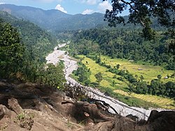
 View of both hills and Terai in Jhapa district | |
 | |
| Country | |
| Province | Koshi Province |
| Admin HQ. | Bhadrapur |
| Government | |
| • Type | Coordination committee |
| • Body | DCC, Jhapa |
| • Head | Mr. Bishwanath Baral |
| • Deputy-Head | Mrs. Shanta Rokka |
| • Parliamentary constituencies | 5 |
| • Provincial constituencies | 10 |
| • Chief District Officer | Chhabilal Rijal [1] |
| Area | |
| • Total | 1,606 km2 (620 sq mi) |
| Elevation (maximum) | 506 m (1,660 ft) |
| Population (2021) | |
| • Total | 994,090 |
| • Rank | 4th (Nepal) |
| • Density | 620/km2 (1,600/sq mi) |
| • Households | 219,989 |
| Demographics | |
| • Ethnic groups | Bahun, Chhetri, Rajbanshi, Gangai or Ganesh Limbu, Rai |
| • Female ♀ | 51.97% |
| • Male ♂/100 female | 92,43 |
| Human Development Index | |
| • Per Capita Income | 1,226 USD |
| • Poverty rate | 21.82 |
| • Literacy | 75% |
| • Life Expectancy | 67.29 |
| Time zone | UTC+05:45 (NPT) |
| Telephone Code | 023 |
| Main Language(s) | Nepali, Rajbanshi, Surjapuri language Limbu, Maithili |
| Major highways | Mahendra Highway, Postal Highway |
| Website | daojhapa |
Jhapa District (Nepali: झापा जिल्ला; ) is a district of Koshi Province in eastern Nepal named after a Rajbanshi Surjapuri language word "Jhapa", meaning "to cover" (verb). The 2021 Nepal Census, puts the total population of the district at 994,090.[3] The total area of the district is 1,606 square kilometres.
The lowlands of Limbuwan (present-day terai lands of Sunsari, Morang and Jhapa) was collectively known as Morang since the time of King Mawrong of 7th century. In the beginning of 1400 AD, Morang Kingdom patriated from Kingdom of Ilam and Kingdom of Mikluk Bodhey (Choubise) and started ruling on its own.[4]
- ^ "Staff Profile of DAO". The Government of Nepal. Retrieved 23 November 2022.
- ^ "Nepal Human Development Report 2014". Npc.gov.np. Retrieved 2022-04-11.
- ^ "Preliminary Report of National Population Census 2021". National Census 2021. National Statistical Office. Retrieved 6 December 2022.
- ^ Chemjong, Iman Singh. History and Culture of Kirat People.