Jiangxia
江夏区 | ||||||||||||||||||||||||||||||||||||
|---|---|---|---|---|---|---|---|---|---|---|---|---|---|---|---|---|---|---|---|---|---|---|---|---|---|---|---|---|---|---|---|---|---|---|---|---|
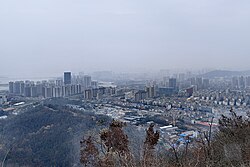
 A view of Jiangxia from the top of Bafen Mountain | ||||||||||||||||||||||||||||||||||||
 | ||||||||||||||||||||||||||||||||||||
| Coordinates: 30°20′23″N 114°18′37″E / 30.3397°N 114.3104°E[1] | ||||||||||||||||||||||||||||||||||||
| Country | People's Republic of China | |||||||||||||||||||||||||||||||||||
| Province | Hubei | |||||||||||||||||||||||||||||||||||
| Sub-provincial city | Wuhan | |||||||||||||||||||||||||||||||||||
| Area | ||||||||||||||||||||||||||||||||||||
| • Total | 2,010.00 km2 (776.07 sq mi) | |||||||||||||||||||||||||||||||||||
| Population (2010)[3] | ||||||||||||||||||||||||||||||||||||
| • Total | 644,835 | |||||||||||||||||||||||||||||||||||
| • Density | 321/km2 (830/sq mi) | |||||||||||||||||||||||||||||||||||
| Time zone | UTC+8 (China Standard) | |||||||||||||||||||||||||||||||||||
| Postal code | 4302XX | |||||||||||||||||||||||||||||||||||
| Wuhan district map |
| |||||||||||||||||||||||||||||||||||
| Website | jiangxia | |||||||||||||||||||||||||||||||||||
Jiangxia District (simplified Chinese: 江夏区; traditional Chinese: 江夏區; pinyin: Jiāngxià Qū) is one of 13 urban districts of the prefecture-level city of Wuhan, the capital of Hubei province, China, situated on the eastern (right) bank of the Yangtze River. Jiangxia district has an area of 2,009 square kilometres (776 sq mi) and a population of 680,000.[4] It is the southernmost and most sparsely populated of Wuhan's districts.[3] It borders the districts of Caidian and Hannan across the Yangtze and Hongshan to the north, as well as the prefecture-level cities of Ezhou to the east, Huangshi to the southeast, and Xianning to the south.
- ^ "Jiangxia" (Map). Google Maps. Retrieved 2014-07-02.
- ^ "Wuhan Statistical Yearbook 2010" (PDF). Wuhan Statistics Bureau. Archived from the original (PDF) on 5 November 2011. Retrieved 31 July 2011.p. 15
- ^ a b "武汉市2010年第六次全国人口普查主要数据公报". Wuhan Statistics Bureau. 10 May 2011. Archived from the original on 25 October 2011. Retrieved 11 July 2011.
- ^ "Profile of Jiangxia District" (in Chinese). Official website of Jiangxia District Government. 2007-05-28. Archived from the original on 2009-05-28. Retrieved 2008-10-15.

