Jo Daviess County | |
|---|---|
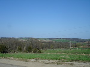
 Hill terrain in the county, part of the Driftless Area | |
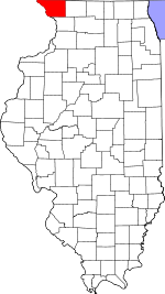
 Location within the U.S. state of Illinois | |
 Illinois's location within the U.S. | |
| Coordinates: 42°22′N 90°13′W / 42.36°N 90.21°W | |
| Country | |
| State | |
| Founded | 1827 |
| Named for | Joseph Hamilton Daveiss |
| Seat | Galena |
| Largest city | Galena |
| Area | |
| • Total | 619 sq mi (1,600 km2) |
| • Land | 601 sq mi (1,560 km2) |
| • Water | 18 sq mi (50 km2) 2.9% |
| Population (2020) | |
| • Total | 22,035 |
| • Estimate (2023) | 21,756 |
| • Density | 36/sq mi (14/km2) |
| Time zone | UTC−6 (Central) |
| • Summer (DST) | UTC−5 (CDT) |
| Congressional district | 16th |
| Website | www |
Jo Daviess County (/ˈdeɪvɪs/) is the northwesternmost county in the U.S. state of Illinois. According to the 2020 census, it had a population of 22,035.[1] Its county seat is Galena.[2] Jo Daviess County is part of the Tri-State Area and is located near Dubuque, Iowa and Platteville, Wisconsin. As part of the Driftless Area, Jo Daviess County contains rugged terrain compared to the rest of the state. Within Jo Daviess County lies Charles Mound, the highest natural point in Illinois, as well as eight of the ten highest points in Illinois.[3][4]
- ^ "Jo Daviess County, Illinois". United States Census Bureau. Retrieved June 9, 2023.
- ^ "Find a County". National Association of Counties. Archived from the original on May 3, 2015. Retrieved June 7, 2011.
- ^ Peak Visor: Jo Daviess County Illinois.
- ^ Peak Visor: Illinois.