Johanngeorgenstadt | |
|---|---|
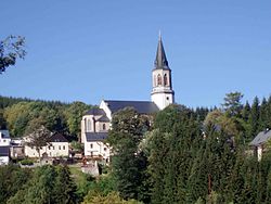
 Exulantenkirche | |
Location of Johanngeorgenstadt within Erzgebirgskreis district  | |
| Coordinates: 50°26′00″N 12°42′50″E / 50.43333°N 12.71389°E | |
| Country | Germany |
| State | Saxony |
| District | Erzgebirgskreis |
| Subdivisions | 12 centres |
| Government | |
| • Mayor (2022–29) | André Oswald[1] |
| Area | |
| • Total | 29.59 km2 (11.42 sq mi) |
| Highest elevation | 1,000 m (3,000 ft) |
| Lowest elevation | 650 m (2,130 ft) |
| Population (2022-12-31)[2] | |
| • Total | 3,783 |
| • Density | 130/km2 (330/sq mi) |
| Time zone | UTC+01:00 (CET) |
| • Summer (DST) | UTC+02:00 (CEST) |
| Postal codes | 08349 |
| Dialling codes | 03773 |
| Vehicle registration | ERZ, ANA, ASZ, AU, MAB, MEK, STL, SZB, ZP |
| Website | www |
Johanngeorgenstadt (German pronunciation: [ˌjoːhan.ɡeˈɔʁgŋ.ʃtat] ) is a mining town in Saxony’s Ore Mountains, 17 km south of Aue, and 27 km northwest of Karlovy Vary. It lies in the district of Erzgebirgskreis, on the border with the Czech Republic, is a state-recognized health resort (Erholungsort), and calls itself Stadt des Schwibbogens (“Schwibbogen Town”). Its population decline since the 1950s has been extremely severe, falling from 45,000 residents in 1953 to only about one twelfth of that now.
- ^ Gewählte Bürgermeisterinnen und Bürgermeister im Freistaat Sachsen, Stand: 17. Juli 2022, Statistisches Landesamt des Freistaates Sachsen.
- ^ "Einwohnerzahlen nach Gemeinden als Excel-Arbeitsmappe" (XLS) (in German). Statistisches Landesamt des Freistaates Sachsen. 2024.


