Jomala | |
|---|---|
Municipality | |
| Jomala kommun | |
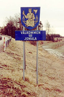
 "Welcome to Jomala." The coat of arms of Jomala features St. Olav sitting on a throne and holding an axe and a globus cruciger | |
 Location of Jomala in Finland | |
| Coordinates: 60°09′N 019°57′E / 60.150°N 19.950°E | |
| Country | |
| Region | Åland |
| Sub-region | Åland Countryside sub-region |
| Government | |
| • Municipal manager | Christian Dreyer |
| Area (2018-01-01)[1] | |
• Total | 687.00 km2 (265.25 sq mi) |
| • Land | 142.73 km2 (55.11 sq mi) |
| • Water | 544.43 km2 (210.21 sq mi) |
| • Rank | 282nd largest in Finland |
| Population (2024-10-31)[2] | |
• Total | 5,768 |
| • Rank | 156th largest in Finland |
| • Density | 40.41/km2 (104.7/sq mi) |
| Population by native language | |
| • Swedish | 87.5% (official) |
| • Finnish | 4.6% |
| • Others | 7.9% |
| Population by age | |
| • 0 to 14 | 21.6% |
| • 15 to 64 | 63.3% |
| • 65 or older | 15.2% |
| Time zone | UTC+02:00 (EET) |
| • Summer (DST) | UTC+03:00 (EEST) |
| Website | www.jomala.ax |
Jomala is a municipality of Åland, an autonomous territory of Finland. In terms of population, it is the next largest after Mariehamn, the capital of Åland.
The municipality has a population of 5,768 (31 October 2024)[2] and covers an area of 687.00 square kilometres (265.25 sq mi) of which 544.43 km2 (210.21 sq mi) is water.[1] The population density is 40.41 inhabitants per square kilometre (104.7/sq mi).
The municipality is unilingually Swedish.
Mariehamn Airport is located in Jomala. Three of Åland's four highways cross the municipality of Jomala as they start from Mariehamn; highway 1 runs west to Eckerö, highway 2 northeast to Sund and highway 3 east to Lumparland.
- ^ a b "Area of Finnish Municipalities 1.1.2018" (PDF). National Land Survey of Finland. Retrieved 30 January 2018.
- ^ a b c "Finland's preliminary population figure was 5,635,560 at the end of October 2024". Population structure. Statistics Finland. 19 November 2024. ISSN 1797-5395. Retrieved 22 November 2024.
- ^ "Population according to age (1-year) and sex by area and the regional division of each statistical reference year, 2003–2020". StatFin. Statistics Finland. Retrieved 2 May 2021.
- ^ a b "Luettelo kuntien ja seurakuntien tuloveroprosenteista vuonna 2023". Tax Administration of Finland. 14 November 2022. Retrieved 7 May 2023.

