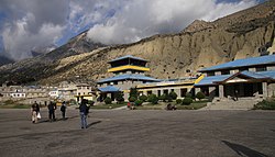
Jomsom Airport जोमसोम विमानस्थल | |||||||||||
|---|---|---|---|---|---|---|---|---|---|---|---|
 | |||||||||||
| Summary | |||||||||||
| Airport type | Public | ||||||||||
| Owner | Government of Nepal | ||||||||||
| Operator | Civil Aviation Authority of Nepal | ||||||||||
| Serves | Jomsom, Gandaki Province, Nepal | ||||||||||
| Elevation AMSL | 8,976 ft / 2,736 m | ||||||||||
| Coordinates | 28°46′56″N 83°43′21″E / 28.78222°N 83.72250°E | ||||||||||
| Map | |||||||||||
| Runways | |||||||||||
| |||||||||||
Jomsom Airport (Nepali: जोमसोम विमानस्थल, IATA: JMO, ICAO: VNJS) is a domestic airport located in Jomsom serving Mustang District, a district in Gandaki Province in Nepal.[1] It serves as the gateway to Mustang District that includes Jomsom, Kagbeni, Tangbe, and Lo Manthang, and Muktinath temple, which is a popular pilgrimage for Nepalis and Indian pilgrims.[4]
- ^ a b Airport information for Jomsom, Nepal (VNJS / JMO) at Great Circle Mapper.
- ^ Jomsom Airport at AirportGuide.com
- ^ FINAL REPORT ON THE ACCIDENT INVESTIGATION OF 9N-ABO ... AT JOMSOM AIRPORT,... ON 16 MAY 2013 Archived 30 April 2016 at the Wayback Machine
- ^ "Nepal plane crash: 11 Indians among 15 dead, Times of India 14 May 2012". The Times of India. Archived from the original on 15 October 2013. Retrieved 14 May 2012.
