| Joondalup Perth, Western Australia | |||||||||||||||
|---|---|---|---|---|---|---|---|---|---|---|---|---|---|---|---|
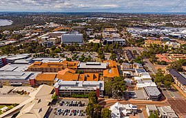
 Aerial view of Joondalup | |||||||||||||||
 | |||||||||||||||
| Coordinates | 31°44′42″S 115°45′58″E / 31.745°S 115.766°E | ||||||||||||||
| Population | 9,193 (SAL 2021)[1] | ||||||||||||||
| Established | 1980s | ||||||||||||||
| Postcode(s) | 6027 | ||||||||||||||
| Area | 11.8 km2 (4.6 sq mi) | ||||||||||||||
| Location | 26 km (16 mi) from Perth | ||||||||||||||
| LGA(s) | City of Joondalup | ||||||||||||||
| State electorate(s) | Joondalup | ||||||||||||||
| Federal division(s) | Moore | ||||||||||||||
| |||||||||||||||
Joondalup (/ˈdʒuːndəlʌp/) is a suburb of Perth, Western Australia, approximately 26 kilometres (16 mi) north of Perth's central business district. It contains the central business district of the regional City of Joondalup and acts as the primary urban centre of Perth's outer northern suburbs.
- ^ Australian Bureau of Statistics (28 June 2022). "Joondalup (suburb and locality)". Australian Census 2021 QuickStats. Retrieved 28 June 2022.