Jorhat district | |
|---|---|
From top, left-to-right: Jorhat aerial view, Lachit Bhawan at Lachit maidam, Dhekiakhowa Bornamghar, Sukapha Samannay Kshetra. | |
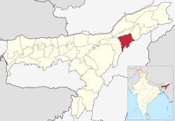
 Location in Assam | |
| Country | |
| State | Assam |
| Division | Upper Assam |
| Headquarters | Jorhat |
| Tehsils | 1. Jorhat East 2. Jorhat West 3. Titabor 4. Teok 5. Mariani |
| Government | |
| • Lok Sabha constituency | Jorhat |
| • Vidhan Sabha constituencies | Jorhat, Titabar, Titabar, Teok |
| Area | |
• Total | 2,852 km2 (1,101 sq mi) |
| Population (2011)[1] | |
• Total | 924,952 |
| • Density | 320/km2 (840/sq mi) |
| Demographics | |
| • Literacy | 83.42 % |
| • Sex ratio | 956 females per 1000 males |
| Time zone | UTC+05:30 (IST) |
| Vehicle registration | AS-03 |
| Major highways | NH-37 |
| Website | jorhat |
Jorhat (pron: ˈʤɔ:(r)ˌhɑ:t) is an administrative district of the Indian state of Assam situated in the central part of the Brahmaputra Valley. The district is bounded by Majuli on north, Nagaland state on the south, Sivasagar on the east and Golaghat on the west. On the north of the district, the river Brahmaputra forms the largest riverine island of the world. The administrative seat is at Jorhat city.
Jorhat was previously a sub-division of undivided Sibsagar district. In 1983, Jorhat was carved out of Sibsagar District and was made a separate district.


